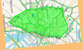
地図で山手線エリアを囲むようなiPhoneアプリのサンプルコードを描いてみます。
動かすとこんな感じです
サンプルコード
#import “ViewController.h”
#import <MapKit/MapKit.h>
@interface ViewController () <MKMapViewDelegate>
@property (nonatomic, weak) MKMapView *map;
@property (nonatomic, strong) NSMutableArray *placemarks;
@end
@implementation ViewController
– (void)viewDidLoad
{
[super viewDidLoad];
[self createMap];
[self createButton];
}
– (void)createMap
{
MKMapView *mv = [[MKMapView alloc] initWithFrame:CGRectMake(0, 0, 320, CGRectGetMaxY(self.view.bounds) – 80)];
mv.delegate = self;
[self.view addSubview:mv];
self.map = mv;
}
– (void)createButton
{
NSArray *names = @[@”showPin”, @”ShowArea”];
SEL selectors[] = {@selector(showPin), @selector(showArea)};
for (int i=0; i<names.count; i++) {
UIButton *btn = [UIButton buttonWithType:UIButtonTypeSystem];
[btn setTitle:names[i] forState:UIControlStateNormal];
[btn sizeToFit];
btn.center = CGPointMake(80 + i*160, CGRectGetMaxY(self.view.frame) – 40);
[self.view addSubview:btn];
[btn addTarget:self action:selectors[i] forControlEvents:UIControlEventTouchUpInside];
}
}
– (void)showArea
{
CLLocationCoordinate2D points[self.placemarks.count];
for (int i=0; i<self.placemarks.count; i++) {
CLLocationCoordinate2D cl = [self.placemarks[i] coordinate];
points[i] = cl;
}
MKPolygon* poly = [MKPolygon polygonWithCoordinates:points count:self.placemarks.count];
poly.title = @”yamanote area”;
[self.map addOverlay:poly];
}
– (void)showPin
{
NSArray *stationNames = [@”大崎 五反田 目黒 恵比寿 渋谷 原宿 代々木 新宿 新大久保 高田馬場 目白 池袋 大塚 巣鴨 駒込 田端 西日暮里 日暮里 鶯谷 上野 御徒町 秋葉原 神田 東京 有楽町 新橋 浜松町 田町 品川“ componentsSeparatedByString:@” “];
self.placemarks = [NSMutableArray array];
for (int i=0; i<stationNames.count; i++) {
dispatch_after(dispatch_time(DISPATCH_TIME_NOW, (int64_t)(i * 0.5 * NSEC_PER_SEC)), dispatch_get_main_queue(), ^{
MKLocalSearchRequest *req = [[MKLocalSearchRequest alloc] init];
req.naturalLanguageQuery = [NSString stringWithFormat:@”%@駅“, stationNames[i]];
MKLocalSearch *search = [[MKLocalSearch alloc] initWithRequest:req];
[search startWithCompletionHandler:^(MKLocalSearchResponse *response, NSError *error) {
for (MKMapItem *item in response.mapItems) {
[self.placemarks addObject:item.placemark];
}
[self.map showAnnotations:self.placemarks animated:YES];
}];
});
}
}
– (MKOverlayRenderer *)mapView:(MKMapView *)mapView rendererForOverlay:(id<MKOverlay>)overlay
{
if (![overlay isKindOfClass:[MKPolygon class]]) {
return nil;
}
MKPolygon *polygon = (MKPolygon *)overlay;
MKPolygonRenderer *renderer = [[MKPolygonRenderer alloc] initWithPolygon:polygon];
renderer.fillColor = [[UIColor greenColor] colorWithAlphaComponent:0.5];
renderer.strokeColor = [UIColor greenColor];
renderer.lineWidth = 5;
return renderer;
}
-(MKAnnotationView *)mapView:(MKMapView *)mapView viewForAnnotation:(id<MKAnnotation>)annotation
{
if ([annotation isKindOfClass:[MKUserLocation class]])
{
return nil;
}
static NSString *reuseId = @”pin”;
MKPinAnnotationView *pav = (MKPinAnnotationView *)[mapView dequeueReusableAnnotationViewWithIdentifier:reuseId];
if (pav == nil)
{
pav = [[MKPinAnnotationView alloc] initWithAnnotation:annotation reuseIdentifier:reuseId];
pav.canShowCallout = YES;
pav.animatesDrop = YES;
pav.pinColor = MKPinAnnotationColorGreen;
}
else
{
pav.annotation = annotation;
}
return pav;
}
– (void)didReceiveMemoryWarning
{
[super didReceiveMemoryWarning];
// Dispose of any resources that can be recreated.
}
@end