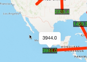

地図のタップした2点に線をひくiPhoneアプリのサンプルコードを描いてみます。
#import “ViewController.h”
#import <MapKit/MapKit.h>
@interface ViewController () <MKMapViewDelegate>
@property (nonatomic, weak) MKMapView *map;
@property (nonatomic, strong) NSMutableArray *points;
@end
@implementation ViewController
– (void)viewDidLoad
{
[super viewDidLoad];
self.points = [NSMutableArray array];
[self createMap];
}
– (void)createMap
{
MKMapView *mv = [[MKMapView alloc] initWithFrame:self.view.bounds];
mv.delegate = self;
[self.view addSubview:mv];
self.map = mv;
}
– (void)touchesBegan:(NSSet *)touches withEvent:(UIEvent *)event
{
CGPoint p = [[touches anyObject] locationInView:self.view];
CLLocationCoordinate2D coordinate = [self.map convertPoint:p toCoordinateFromView:self.view];
[self.points addObject:[NSValue valueWithMKCoordinate:coordinate]];
if (self.points.count % 2 == 0) {
[self addLineOverlay];
}
[super touchesBegan:touches withEvent:event];
}
– (void)addLineOverlay
{
CLLocationCoordinate2D points[4];
points[0] = [self.points[self.points.count – 2] MKCoordinateValue];
points[1] = [self.points[self.points.count – 2] MKCoordinateValue];
points[2] = [[self.points lastObject] MKCoordinateValue];
points[3] = [[self.points lastObject] MKCoordinateValue];
MKPolygon* poly = [MKPolygon polygonWithCoordinates:points count:4];
poly.title = [NSString stringWithFormat:@”%lu”, self.points.count];
[self.map addOverlay:poly];
}
– (MKOverlayRenderer *)mapView:(MKMapView *)mapView rendererForOverlay:(id<MKOverlay>)overlay
{
if (![overlay isKindOfClass:[MKPolygon class]]) {
return nil;
}
MKPolygon *polygon = (MKPolygon *)overlay;
MKPolygonRenderer *renderer = [[MKPolygonRenderer alloc] initWithPolygon:polygon];
renderer.fillColor = [[UIColor redColor] colorWithAlphaComponent:0.5];
renderer.strokeColor = [UIColor redColor];
renderer.lineWidth = 10;
int idx = [polygon.title intValue];
CLLocationCoordinate2D p1 = [self.points[idx-2] MKCoordinateValue];
CLLocationCoordinate2D p2 = [self.points[idx-1] MKCoordinateValue];
CLLocation *l1 = [[CLLocation alloc] initWithLatitude:p1.latitude longitude:p1.longitude];
CLLocation *l2 = [[CLLocation alloc] initWithLatitude:p2.latitude longitude:p2.longitude];
CLLocationDistance dist = [l1 distanceFromLocation:l2];
MKPointAnnotation *annotation = [[MKPointAnnotation alloc] init];
annotation.coordinate = p2;
annotation.title = [NSString stringWithFormat:@”%.1f”, dist / 1000];
[self.map addAnnotation:annotation];
return renderer;
}
-(MKAnnotationView *)mapView:(MKMapView *)mapView viewForAnnotation:(id<MKAnnotation>)annotation
{
if ([annotation isKindOfClass:[MKUserLocation class]])
return nil;
static NSString *reuseId = @”reuseid”;
MKAnnotationView *a = [mapView dequeueReusableAnnotationViewWithIdentifier:reuseId];
if (!a)
{
a = [[MKAnnotationView alloc] initWithAnnotation:annotation reuseIdentifier:reuseId];
UILabel *l = [[UILabel alloc] init];
l.backgroundColor = [[UIColor blackColor] colorWithAlphaComponent:0.6];
l.textColor = [UIColor greenColor];
l.text = annotation.title;
[l sizeToFit];
[a addSubview:l];
a.canShowCallout = YES;
a.frame = l.frame;
l.tag = 1;
}
else
{
a.annotation = annotation;
}
return a;
}
@end